Canopy Cover Assessment
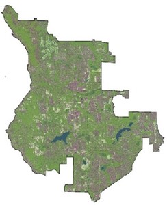
As part of the Urban Forest Management Plan, the City of Sammamish completed a full canopy cover assessment. This evaluates how much of the city is covered by trees.
This assessment helps the City better understand its urban forest resources. It establishes a benchmark to compare future data against. Having a baseline will let the City measure its progress in meeting the goals in the Urban Forest Management Plan. The assessment also helps develop tools for making better decisions about tree management.
An interactive "StoryMap" presents data from the canopy cover assessment, including:
- the tree canopy (how many trees there are)
- forest fragmentation (whether there are large stands of trees connected together, or small patches that don't connect)
- tree canopy health (how healthy the trees in Sammamish are)
- priority planting areas (where tree planting may take place)
Work was completed with the University of Washington's Urban Ecology Research Lab and the Davey Resource Group's Geographic Information System (GIS) team. The StoryMap was created by the Davey Resource Group.